Each summer, the University of Rhode Island Graduate School of Oceanography (GSO) hosts undergraduate students from all over the country to participate in oceanographic research. These Summer Undergraduate Research Fellows (SURFOs) have not only been working with GSO scientists, but they have spent part of their time learning how to communicate this science to the public. Read on to find out what they have been up to, and why they everyone should be as excited as they are about their work.
This post was written by Ben Watzak. This summer, Ben was a summer intern (SURFO) working in Dr. Matt Wei’s lab. He is also a senior at Texas A&M University, majoring in applied mathematics and minoring in oceanography and Spanish. You can find out more at https://sites.google.com/tamu.edu/benwatzak/home.
— — — — — — —
The Issue
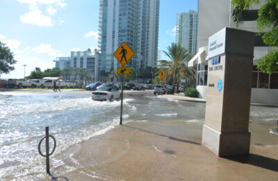
Because sea level rise is an ongoing problem, we as a global community have a responsibility to look at it more seriously. We must begin to accept that the issue exists, and then work towards solutions. In order to be proactive about handling the issue, we need to know what to expect. Unfortunately, there is a deficit of data that hinders our ability to make predictions. A cheap, yet effective, method of observing sea levels is much needed.
If you live near the coast or a river, you’re likely aware that sea level rise is an issue. Perhaps you’ve only heard of it, but don’t really know the magnitude of its impacts on you or your community. Then you are not unlike most people; we know that the water will rise, but we don’t have a good idea of how much or at what rate it will do so. Much like weather forecasts, oceanographers use models that are driven by real measurements to predict these things. The more data we have, the more accurate a model gets.
It seems simple enough: collect more data and get better predictions. The National Oceanographic and Atmospheric Administration (NOAA) has several tidal gauges in place around the United States. These measure water levels, among other things, very accurately and very often. Some of the stations have even been around for almost a century! So, it seems only natural to put more of these stations in place along the coastline so as to obtain more observations of water level. However, the tricky part about science is that it gets very expensive, very quickly. Tidal gauge stations are expensive to implement, and require a lot of maintenance and recalibration over time. In recent years, people have discovered a cheaper alternative: navigation system tracking.
A Solution
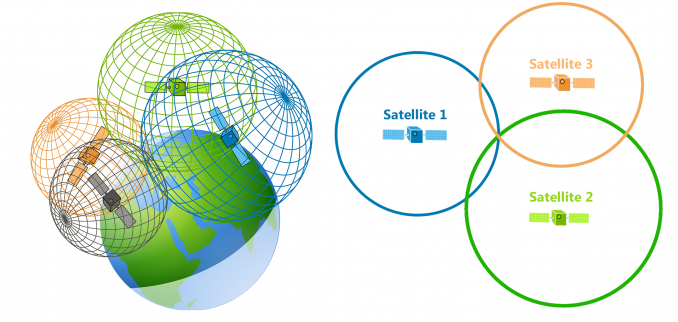
A Global Navigation Satellite System (GNSS) tracker measures the time it takes for a signal to get from the satellite to the receiver, then calculates the distance between itself and the satellite. When the receiver has 3 or more signals, it can find its position. If you are from the USA, you’ve undoubtedly heard of the Global Positioning System (GPS). But you may be surprised to learn that GPS is just one of many GNSS “constellations,” as they are called. GPS is owned, operated, and funded by the US government. Meanwhile, Russia, the European Union, and China each have their own GNSS that works in same way. We can use all of these GNSS constellations, when and wherever they are available, to obtain more precise measurements. After all, as previously stated, more data makes for better models and predictions.
Interestingly, GNSS can be used for more than road trips and Pokémon Go. Remember the time you took a hike to go see the lake that had a perfect reflection of the landscape on it? Or maybe you’ve had to wear sunglasses in a snow-covered area because the glare from the sun off of the surface was just too much. Well, the same thing that happens to light happens to satellite signals! When they hit a reflective surface, such as water or ice on the earth, they bounce back up toward space. This means that a GNSS receiver can observe/record both a direct signal and a reflected signal. Though this used to cause headaches for those looking to precisely track a position, it is now considered useful in the field of GNSS Interferometric Reflectometry, which uses GNSS to observe changes in the environment.
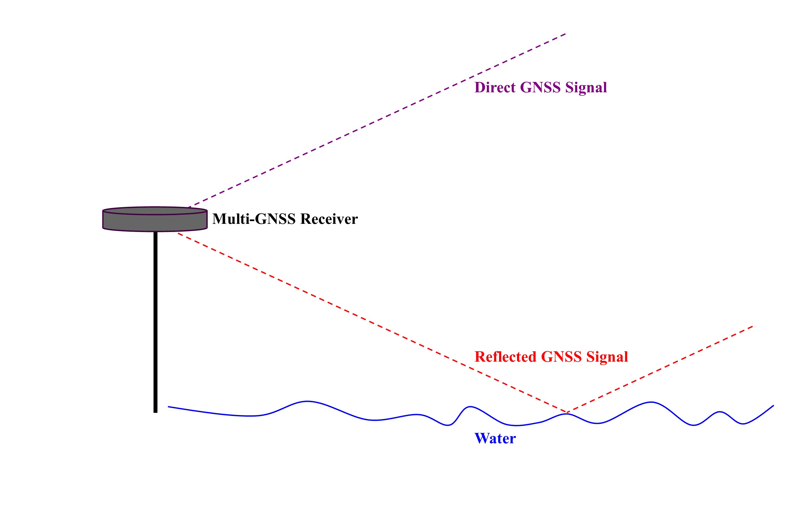
When a GNSS receiver is placed close to a reflective surface, it can be used to measure the distance between itself and the surface. With a little bit of geometry and calculus, a computer program can easily use the time delay between when the direct signals and the reflected signals arrive to calculate this distance. When situated near surface water, a GNSS tracker can effectively give us water levels. I have been analyzing these water level readings this summer, and they are surprisingly accurate. When compared to tidal gauge measurements, the two water levels are almost perfectly aligned!
By placing these GNSS trackers all along the coastline, we can create a dense dataset of water levels, at relatively low cost. This will greatly improve the data that the scientific community has and will allow for us as a society to better understand the ongoing process of sea level rise. We can then be better informed on what is to come, allowing governments and communities to better prepare everyone for the future.
I’m a PhD student at the University of Rhode Island’s Graduate School of Oceanography. I use a small-scale computer model to study how physical features like surface waves at the air-sea interface produce friction for the wind that can limit momentum, energy, gas, and heat exchange between the ocean and atmosphere. In the future, I hope to learn more about the role waves play in different parts of the world as weather and climate patterns evolve. Also, I love to write.