What is a Harmful algal bloom?
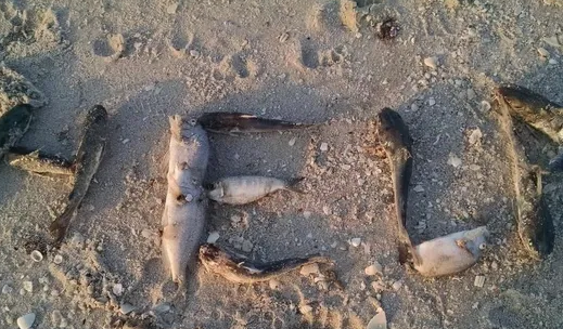
Harmful algal blooms, or HABs for short, come in many different forms. They can form when there are high concentrations of nutrients in the water encouraging phytoplankton to grow rapidly. When the large bloom of phytoplankton dies, bacteria eat up the dying matter and use up oxygen in the surrounding water, causing problems for larger organisms, such as fish, who need oxygen to survive. There are also species of phytoplankton that can produce harmful toxins. These toxins get incorporated into shellfish or fish that can post a threat to human health if ingested. HAB events are increasing in duration and severity. In fact, the HAB that occurred in in Florida from 2017-2018 is considered to be the worst on record. The researchers of this study are developing new methods for understanding these harmful algal blooms such as the one that occurred in Florida.
The Backstory of HABs on Florida’s coasts

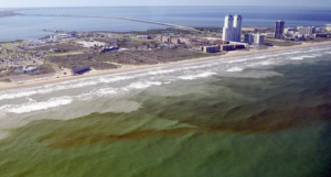
“Disheartening is a good word to describe summer 2018 in southwest Florida.” This line comes from Amy Bennett Williams, a reporter from Fort-Meyers News-Press, who wrote this article about the harmful algal blooms that hit Florida’s coast hard in 2017-2018 and continue to be a problem there. Toxins produced by Karenia brevis were felt from miles when they became transported by wind and caused people to develop asthma-like symptoms from respiratory irritation. Currently, scientists are concerned with the lack of long-term HAB data because this prevents them from being able to predict when a HAB may develop. However, with the development of new technology, like the sailboat vessel described in this research, inexpensive long-term monitoring of HABs may be possible and enable better preparedness for these events in the future.
Monitoring HABs
There are many different methods used to monitor HABs, such as satellites or fixed-location mooring devices. Satellites are inexpensive but they don’t have good temporal or spatial resolution and can be hindered by clouds. Fixed-location, unattended monitoring devices provide good temporal resolution, especially to the species level; however, the installation of enough of these fixed instruments to make it worth it would be expensive. This study focused on the development of a sailboat monitoring platform for detecting HABs in shallow coastal ecosystems. To the authors’ knowledge, all existing long duration autonomous vehicles are not designed to operate effectively in shallow waters less than a few meters depth. These shallow regions are often where HABs occur, so it is important to be able to expand monitoring efforts here. To do this, Mote Marine Lab began a collaboration with Navocean, Inc. to utilize their autonomous sail-powered surface vehicle for Karenia brevis bloom monitoring on the coast of Florida.
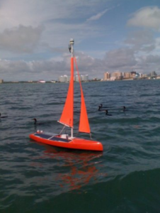
The Nav2 vehicle
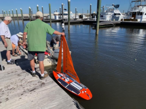
The vessel used for HAB monitoring is called the “Nav2” and is powered by renewable resources. It is inexpensive, able to be navigated in shallow waters (<1m) and deployable from shore by a single person. The base cost of the vessel is 75,000, which is cheap for oceanographic monitoring! The Nav2 is easily controlled via an iOS application (on an iPhone or iPad) that can be in constant communication to the vessel using Wifi. The operator only needs to monitor the vessel a few times per day to ensure that the mission goals are being met.
Using the Nav2 to monitor HABs
There were multiple sensors placed on the Nav2 for monitoring HABSs. A fluorometer was used to monitor the concentration of chlorophyll-a, which is a pigment of phytoplankton that can be used as a proxy for algal presence. This study focused on three deployments of the Vav2 vessel that increased in duration each time. The first deployment was 1 day, then 3 days and then 1 week long. The purpose of these “missions” was to map spatial HAB bloom patterns in localized regions, locate hotspots, and determine bloom patchiness. The Nav2 vessel proved to be a good platform for unattended monitoring of the coastal surface ocean. The vessel’s small size allows it to get close to shore, where many fish and oyster farms are located and susceptible to HABs.
The Nav2 vessel platform was used for the specific species of K. brevis. These blooms are hard to monitor because they are most destructive nearshore but can be transported shoreward from deeper waters. In addition, cell concentrations of K. brevis can vary by an order of magnitude just a few meters apart, so these blooms are extremely patchy. In the past, monitoring efforts of deeper waters have been conducted with autonomous gliders but these are expensive to maintain and they cannot provide high resolution coastal measurements. Thus, the Nav2 is a great option for monitoring HABs in coastal waters. This was the first demonstration of a reliable mobile platform for wide-area coastal HAB monitoring and this technology is a promising option for the future as HAB events may continue to increase. If we have the ability to fully monitor HAB events in real-time using renewable-energy powered vessels, we may be able to predict when these bloom events will occur, enabling the proper management procedures.
I love writing of all kinds. As a PhD student at the Graduate School of Oceanography (URI), I use using genetic techniques to study phytoplankton diversity. I am interested in understanding how environmental stressors associated with climate change affect phytoplankton community dynamics and thus, overall ecosystem function. Prior to graduate school, I spent two years as a plankton analyst in the Marine Invasions Lab at the Smithsonian Environmental Research Center (SERC) studying phytoplankton in ballast water of cargo ships and gaining experience with phytoplankton taxonomy and culturing techniques. In my free time I enjoy making my own pottery and hiking in the White Mountains (NH).