Pilar Madrigal, Kaj Hoernle, Brian R. Jicha, Christian Timm, Dieter Garbe-Schönberg, William W. Sager, Folkmar Hauff, Maxim Portnyagin, Gene Yogodzinski; Early Emperor seamount evolution and geotectonics of the northwestern Pacific plate. Geology 2025; 53 (12): 1023–1028. doi: https://doi.org/10.1130/G53477.1
Plate tectonics control oceanography
Plate tectonics is the movement of the large, rigid plates that makeup Earth’s outer shell (where we live!) over the less rigid interior of the Earth. It is also responsible for the physical evolution of our planet through earthquakes, mountain building events, and the creation and destruction of crust via volcanism. As oceanographers, it is extremely important to understand the concept of plate tectonics to be able to describe the formation of our ocean basins and other phenomena that occurs in oceanographic disciplines other than geology. For example, it is plate tectonics and the geology of the seafloor that governs the physics behind ocean currents and how they change.
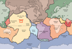
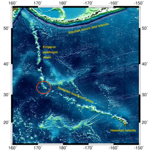
Geological oceanographers have continued to find creative ways to learn more about the tectonic history of our planet (e.g., plate reconstruction models, geochemical analyses, matching fossils found on multiple continents). Even so, there are some regions of the ocean basins whose history has not been well constrained due to a lack of samples. One of those areas is the northwestern region of the Pacific plate (large yellow area in Fig. 1). This region is home to the Emperor Seamounts of the Hawaiian-Emperor Seamount Chain (HESC; Fig. 2). While we know a lot about Hawaii because the volcanic islands are active, populated, and easy to sample, we don’t know a lot about the formation of the northernmost Emperor seamounts because they are in a remote region of the ocean. An apparent bend in the HESC indicates a clear change in the direction of motion of the Pacific plate (Fig. 2). Thus, seamounts on either side of the bend may hold major implications about the evolution of the Pacific Ocean basin.
New samples add to the story
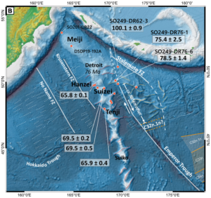
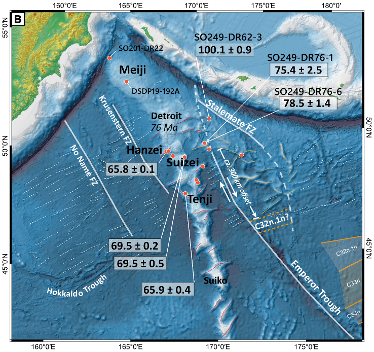
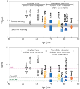
Madrigal and the science team set out to map and sample four northern Emperor seamounts that hadn’t been researched before (Meiji, Hanzei, Suizei, and Tenji), in addition to a few other features called volcanic elongated ridges (VERs). VERs are features associated with volcanism caused by the separation of two pieces of tectonic plate (spreading ridges). The team used a dredge, a big metal basket that drags along the seafloor collecting rocks, to complete their sampling. Once the lava samples were back at the lab, scientists analyzed them for their chemical makeup and age to help reconstruct the region’s tectonic history.
Age-wise, the authors found that the seamounts were generally formed in chronological order with the features getting older as you move north (Fig. 3). Chemically, the seamounts and VERs displayed a wide range of compositions (Fig. 4) indicating that they were formed differently than the seamounts to the south and the modern-day lavas produced by the hotspot plume under the Big Island of Hawaii (ocean island basalts, or OIBs). As suspected, the VERs have the chemical composition of mid-ocean ridge basalts (MORB), the type of rock found at spreading ridges. Samples from the four seamounts and another previously sampled site (Detroit seamount) show decreasing elemental ratios as you move north indicating the interaction and mixing of VER spreading ridge and hotspot plume sources to different degrees along the Emperor Seamount Chain.
Complex tectonics
Ultimately, this study reveals the region has undergone a complex tectonic evolution over the last ~82 million years involving volcanism from two types of sources, a spreading ridge and a hotspot plume. This highlights that the geology of our ocean basins is constantly changing, altering the physical, chemical, and biological patterns we may observe which can control things like our planet’s climate. Therefore, unveiling tectonic history allows us to refine our understanding of all oceanographic processes and how their intertwined nature influences large-scale changes in other Earth processes.
Cover image is the same as Fig. 3.
I am a Ph.D. Candidate in Geological Oceanography at the University of Rhode Island, Graduate School of Oceanography. I received my B.S. in Geology from Union College (NY). I study submarine volcanoes! I use the chemical composition of lava to figure out what is happening inside the Earth and how magma is formed. When I’m not working with rocks, I enjoy reading on the beach, cooking, and hiking.