Article: Rhawn F. Denniston et al. (2015). “Extreme rainfall activity in the Australian tropics reflects changes in the El Nino/Southern Oscillation over the last two millennia”. In: Proc Natl Acad Sci USA 112.15, pp. 4576-4581. doi: 10.1073/pnas.1422270112. url: http://dx.doi.org/10.1073/pnas.1422270112
El Niño Primer
Did you know that there’s a large mass of water that sloshes back and forth across the Pacific Ocean, like water in your bathtub? You may be wondering what that has to do with tropical cyclones, time machines, or Australia. Let me take a moment to get you up to speed on that sloshing water, and I’ll explain!
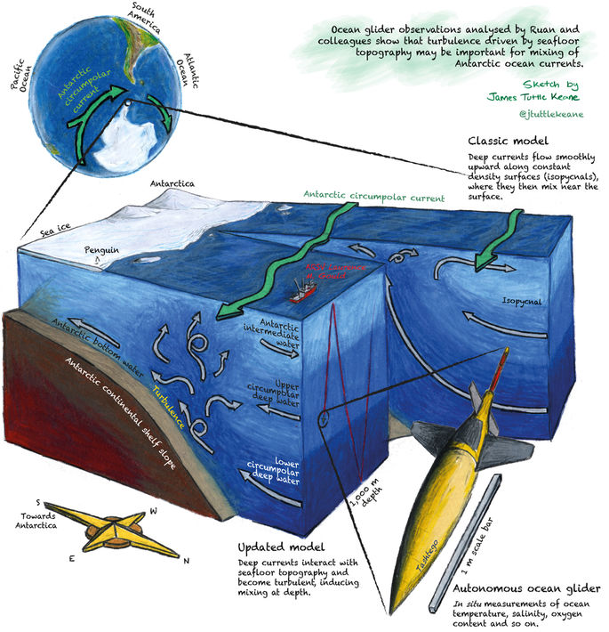
The official name for this sloshy pattern of water movement is the El Niño Southern Oscillation (ENSO), and one cycle of the pattern happens about every 2-7 years, when the winds change across the Pacific Ocean. Usually, strong trade winds blow from east to west across the Pacific, which sets up a pattern of wet, humid, rainy weather near Hawaii and Indonesia, and dry, cool weather off the coast of South America. In the ocean, these winds result in upwelling off South America, where cold, deep waters are pulled up to replace surface waters that have been blown towards the west. In an El Niño year the strong east-west trade winds weaken and reverse, and water upwelling near South America stops. From space, this looks like a big pool of warm water sloshing from Indonesia to South America, and then back again when the trade winds kick back up. This pattern also affects weather and the ocean near globally through changes in the atmosphere. For a more detailed explanation of ENSO, please see the narrated animation below.
Cyclones and El Niño
Tropical cyclones (know as hurricanes in the Atlantic) are fueled by warm surface ocean waters. This makes the distribution of the warm waters of the Pacific influential in the strength or frequency of tropical cyclones. During an El Niño cycle, when the eastern Pacific is warmer, less favorable conditions for tropical cyclones occur in the areas where Atlantic and Australian storms form. During a La Niña event (the opposite of an El Niño), when the eastern Pacific Ocean becomes cooler than average, more favorable conditions for tropical cyclone formation occur.
Indeed, this link between ENSO and tropical cyclone activity is well documented for the span of recent history covered by satellite observations of tropical cyclones and sea surface temperatures. However, since these observations only go back around 50 years, scientists don’t have enough data to pick out longer-term relationships between ENSO and tropical cyclones. For those working to construct climate models to predict what our planet will be like in the future, this poses a problem: is the recent link between ENSO and tropical cyclones a strong, persistent climate feature, or a short term anomaly? Considering the impacts of tropical cyclones on coastal communities and their role in transferring energy around the globe, it is important for climate models to accurately represent this relationship. Recently, a team of scientists has looked to the unlikely sounding location of a North Australian cave to find answers about the history of the link between ENSO and cyclones.
Methods
To get a better idea of how long ENSO events have been driving variability in tropical cyclones, a team of scientists climbed into a cave named KNI-51 (Fig. 1), and extracted stalagmites, columns of rock formed over thousands of years from sediment deposited by water dripping from the cave ceiling (Fig. 2, right). During high rainfall events, such as tropical cyclones, KNI-51 floods and fills with muddy water. This mud leaves a fine sediment layer on the stalagmite surface as the flood waters recede, which is then slowly covered over by the normal stalagmite growth process (Fig. 2, left). By measuring the amount of a radioactive isotope (238-Th for those interested) on either side of the mud streak, scientists can accurately determine the date of the flooding to within about 20 years. The team was able to construct a history of flooding events for the last 2,200 years from seven stalagmites, a far longer period than the 50 years current satellite observations allow.


Some readers may be asking, “So how do we know the floods were caused by tropical cyclones?” This is a very good question, considering the area is also impacted by a monsoon season that can produce large amounts of rain. To tease out the tropical cyclone events, the team also used a rainfall record from a nearby weather station to check the correlation between tropical cyclones and the more recent flood events captured in the stalagmites. Historical tropical cyclones matched well with the majority of the highest rainfall events from the stalagmites, giving the scientists a baseline of the level of flooding needed to create the mud layers observed. From this, they concluded that most of the mud layers had been caused by tropical cyclones.
Findings
Analyzing the reconstructed record of tropical cyclones pulled from the stalagmites, the team found that the periods of high tropical cyclone activity synchronized with similar reconstructed records from other sources around the globe (Fig. 3). For instance, the Australian record indicates increased tropical cyclone activity in the 9th through 14th centuries, which matches well with tropical cyclone history reconstructions from the Gulf of Mexico and the Caribbean produced from similar sediment deposits (Fig. 3 A-D). The Australian record also corresponds with records of ENSO events in other areas (Fig.3 E,F). This suggests that the ENSO/tropical cyclone link is something that has been occurring for a long time on a global scale.

Broader Impacts
Climate modelers can use this information to better tune their models, drawing on a longer-term relationship between ENSO events and tropical cyclones. This will hopefully enhance their ability to predict what comes next for our planet in terms of storm intensity, frequency, and distribution around the globe. In turn, communities will be better prepared to take precautionary measures to prepare if needed.
Austen Blair is a MS candidate at the University of Rhode Island Graduate School of Oceanography. While his current research focuses on the influences of wave fields in a hurricane-wave-ocean model, he enjoys the many interdisciplinary opportunities the field of oceanography provides. When not doing research, you can find him on the water, rock climbing, or on his bike.