Reviewing: Bell, K. L. C., K. N. Johannes, B. R. C. Kennedy, and S. E. Poulton. 2025. How little we’ve seen: A visual coverage estimate of the deep seafloor. Science AdvAnceS.’
When you imagine the deep sea, what do you picture? Deep, dark, cold, high pressure, far from land? Those features that define the deep sea are the same factors that challenge our ability to study it. Two early researchers in the field, Gage and Taylor, said, “our methods of study [for the deep sea] are inhibited by the need for our instruments and observation chambers to be encapsulated in the atmosphere of the surface, and strengthened against the crusting pressure of the water column several kilometers in height”. The deep sea, 200 – 10,000 m deep, is below the limit of scuba diving, making studying this ecosystem more akin to studying outer space; we must rely on technological advancements to describe this bizarre habitat.
How to see under the sea
Early explorers in the mid-1800s were interested in mapping the seafloor and primarily accomplished this by dropping weighted ropes off the side of the boat and releasing a line until it hit the bottom. From these pinpoint depth readings, maps were created that illustrate the topography, or shape of the seafloor, including the continental shelf and slope, trenches, seamounts and canyons. They also outfitted overboard ropes with various early sensors for temperature and salinity and performed simple dredging to scoop up mud and animals. These early tools and expeditions, namely the HMS “Challenger”, from 1872 to 1876, were pivotal in generating curiosity for deep-sea research, with many countries starting deep-sea research programs in the early 1900’s, especially in Europe and the U.S., and fueling a sense of nationalism around deep-sea research. From the late 1800s to the mid-1900s, improved analog tools and their associated data formed modern oceanography, including improved dredging equipment for physical samples, acoustics to produce better maps, and a swath of sensors to collect different water properties continuously. Go explore a full history of sea-going research through NOAA Ocean Exploration!

The dawn of the electronic age, from the 1950s onward, introduces underwater manned (i.e., submarines in 1964) and unmanned (i.e., robotic cameras in the 1970s) vehicles as deep-sea research tools and allows scientists to see the deep sea for the first time. Imagine being in a submarine when scientists first lay eyes on glittering lights from bioluminescent fish, bubbling hydrothermal vents, mosaics of deep-water corals, sunken whale skeletons housing diverse life, eerie brine pools, or fields and fields of polymetallic nodules housing a great variety of life! Our knowledge of deep-sea ecosystems has skyrocketed with visual surveys, as the authors of the journal reviewed today state, “with each subsequent dive and observation, the scale of biodiversity and geology of the ocean floor are expanding and redefined”. … and yet, how much of the deep sea have we explored in this relatively short time?

Getting to the bottom of things
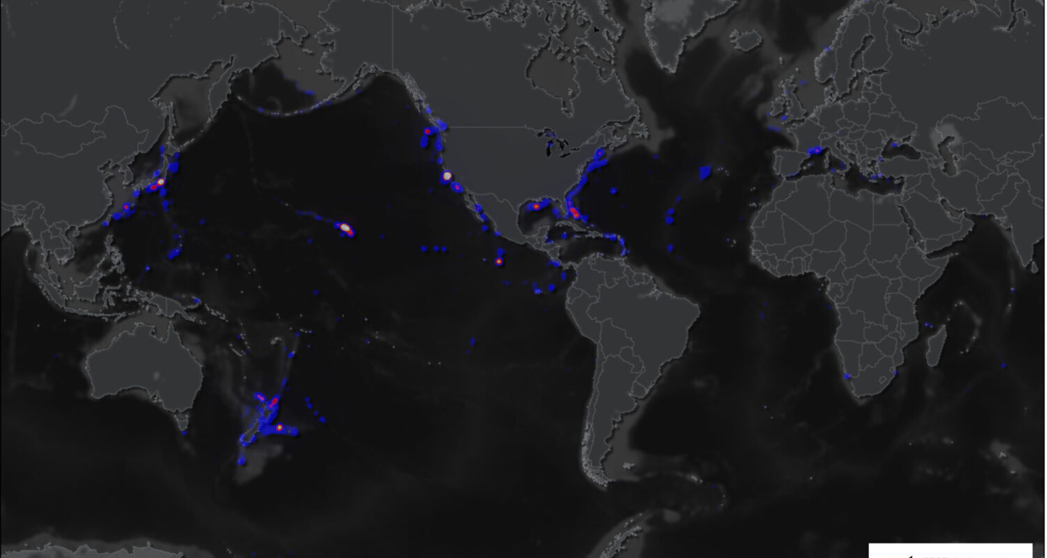
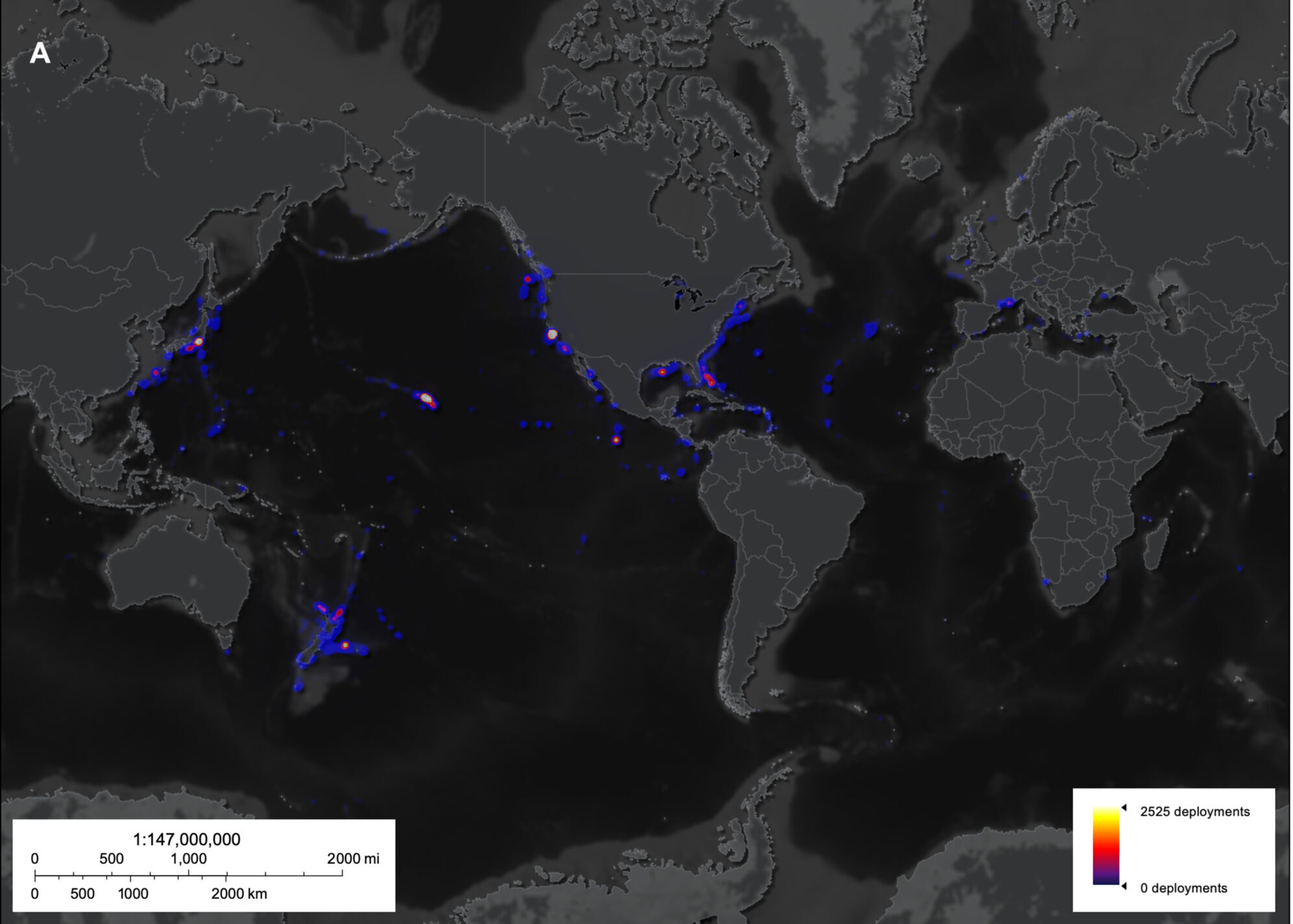
The deep sea begins at depths where light starts to diminish, about 200 m or 675 ft deep, and spans the space between continents. Covering over 65% of Earth’s surface, the deep-sea is Earth’s the largest ecosystem! Dr. Katy Croff Bell and colleagues assembled a global dataset of every visual survey conducted in the deep sea to assess current progress in exploring this ecosystem. A total of 43,681 recorded visual surveys were accounted for, from a total of 34 institutions in 14 countries, with the first record dating back to as early as 1958. They asked the following questions: What countries perform the most deep-sea research? Where is most deep-sea research located? And how much of the deep seafloor have we documented globally?
How deep are we?
Deep-sea activity has increased substantially since the 1960s, almost up to 4x by the mid-2010s. Most research is conducted by five wealthy countries: the United States, Japan and New Zealand, France, and Germany. Most studies have been conducted within the national jurisdiction of those countries rather than the vast international waters where most of the deep sea is found. The most bottom-time, or time spent sampling, has occurred at the shallowest zone of the ocean, the twilight zone (200 – 1000 m deep). This depth zone only represents about 10% of the deep sea, yet 42.6% of total research has been conducted here. In contrast, the majority of the deep sea is within the abyssal zone (4000-6000 m deep), yet only 5.5% of deep-sea dives have occurred at these depths. This difference in bottom time versus habitat coverage suggests that our perception of the deep sea is biased towards shallow depths. The total area of the deep sea that has been visually surveyed equates to 3,823 km2, which roughly equates to the size of the U.S. state of Rhode Island or 10% of the country of Belgium. Globally, the researchers estimate that only 0.01% of the deep seafloor has been studied, which means that over 99.99% of Earth’s surface is undocumented and likely filled with discoveries to be made!
Are we headed up?
The deep sea is enormous, and our discoveries thus far only scratch the surface of what is to be discovered. Research led by Dr. Bell and colleagues demonstrates this, in addition to who has been leading this research. The authors state, “as exploration increases in the deep ocean, so does the potential for discoveries that will continue to benefit humanity”. The deep sea is globally important for the various ecosystem services it provides that benefit all: climate regulation, cultural heritage, food production, carbon sequestration, mineral and energy resources, and even pharmaceutical compounds! Despite the global services the deep sea provides, knowledge is held among only a handful of entities and a few specific locations! The history of deep-sea technology has demonstrated how critical increases in knowledge are, and we should expect that increased resources for deep-sea research would vastly improve what we already know. This disparity of knowledge means that currently, not all countries have access to data to predict what might happen to the deep-sea around them, nor are we in a position globally to predict what might happen to the deep-sea under climate change or other global phenomena.
What do you think? Have we measured enough of the deep sea? Where in the deep sea would you like to visit and study if you had a submarine?
I am a recent PhD grad in Biological Oceanography at the University of Hawaiʻi at Mānoa. I study the community ecology of abyssal animals across space, time, and habitat, and I ask questions often with regard to human impact, specifically deep-sea mining.