Chai, F., Johnson, K.S., Claustre, H. et al. Monitoring ocean biogeochemistry with autonomous platforms. Nat Rev Earth Environ 1, 315–326 (2020). https://doi.org/10.1038/s43017-020-0053-y
While it once seemed inconceivable that humans could alter the vast ocean, it is now indisputable that our activities are causing rapid changes. Excessive emissions of fossil fuels are transforming the very chemistry of the ocean, causing it to heat up, acidify, and lose oxygen. These changes have myriad ripple effects, from increased storm intensity to the loss of marine habitats and species. At the same time, human dependency on ocean resources—from fish to minerals to energy—has increased dramatically in recent decades.
Recognizing that our collective treatment of the ocean is not sustainable, the United Nations has proclaimed that this year will mark the start of a Decade of Ocean Science for Sustainable Development. The overarching goals of the Decade of Ocean Science are to better understand how the ocean responds to human pressures and to reverse the decline in ocean health. Achieving these goals will require “…a shared information system, based on trustworthy, science-based data, from all parts of the world’s ocean”, as stated by Peter Haugan, former chair of the Intergovernmental Oceanographic Commission.
Ocean Eyes
Monitoring long-term changes across the entire world’s ocean is no easy feat. Historically, marine scientists have studied the ocean on ship expeditions, directly observing marine life and manually collecting measurements. More recently, moorings have acted as observational platforms at fixed locations in the ocean, providing information on how the ocean affects climate and weather. Over the past four decades, satellites have also become indispensable in how we “see the sea”, giving us a birds-eye view of its features.
While these traditional observing systems have provided us with valuable insights, they have several shortcomings. Ships are limited in where and when they can travel, and expeditions are extremely expensive, costing up to $40,000 a day. Because moorings are situated at fixed locations, they can’t provide large-scale spatial coverage nor track moving water masses. Satellites can only resolve features at the sea surface, missing out on what is going on below, and pesky clouds can interfere with data collection.
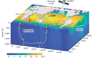
To develop a truly global, long-term ocean observing system, we require sampling platforms that can cover the entire span and depth of the ocean. In a recent article published in Nature Reviews Earth & Environment, Fei Chai and co-authors make the case for developing new technologies—specifically, autonomous platforms—to compliment traditional measurement methods in our quest to better understand the ocean.
Enter the Robots
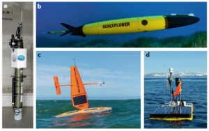
In recent years, several new autonomous platforms have been developed, including Argo floats, gliders, and unmanned surface vehicles (USVs). Their allure lies in the fact that they can traverse the ocean wielding sensors for various measurements, without the need for humans. These ocean robots can operate in harsh environments—even under sea ice—and in all-weather conditions. Furthermore, they can capture transient events that may be missed by ships or satellites, such as ecosystem responses in the aftermath of a tropical storm. Autonomous platforms promise to fill in the gaps from their traditional counterparts and revolutionize how we study the ocean.
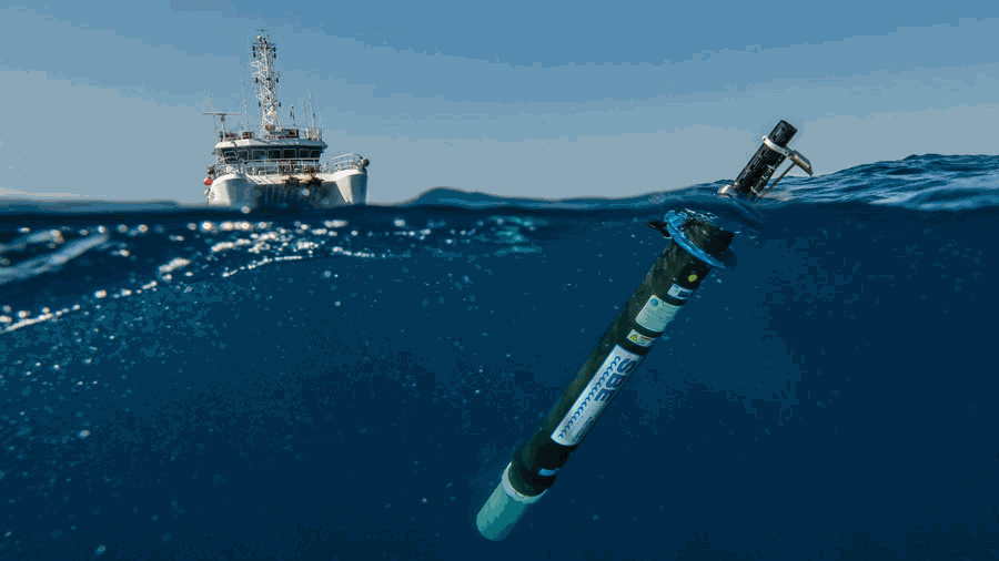
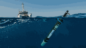
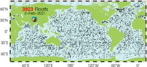
Argo floats drift passively with ocean currents and are equipped with sensors to measure temperature, salinity, and pressure. During a typical 10-day mission, an Argo float collects profiles from the surface to 1,000-2,000 meters depth and transmits its data in near-real time via satellite. Over the past two decades, Argo floats have tracked the rise in ocean temperatures due to human-induced climate change. Today, the international Argo fleet is ~4,000 strong, providing snapshots of physical ocean conditions every few days. There has been a recent push to equip Argo floats with biogeochemical sensors to measure parameters such as oxygen, nitrate (a key nutrient), and pH (acidity). These new Biogeochemical (BGC) Argo floats will allow us to tackle the question of how warming water temperatures will alter the chemistry of the ocean.
Ocean gliders are similar to Argo floats, except that they have fins that allow them to be steered automatically. Whereas Argo floats profile the open ocean, gliders are typically deployed closer to shore. Gliders can travel far distances over long periods without servicing, conducting uninterrupted missions for up to 1 year. They can sample the ocean where it is impractical to send humans and can even operate in the middle of a hurricane, making them ideal platforms for storm research and forecasting.
Unmanned Surface Vehicles (USVs) are robotic boats that can measure meteorological variables and surface ocean conditions across ocean basins. These platforms, which include saildrones and Wave Gliders, are more flexible than moorings but far cheaper than ships. As their names imply, saildrones use wind for propulsion while Wave Gliders are powered by wave energy.
Trial BGC-Argo floats have already been deployed by the international research community. In 2019, floats profiling the Southern Ocean discovered massive blooms of phytoplankton that were fueled by iron emitted by hydrothermal vents, or hot springs on the sea floor. Typically, nutrients were thought to come from land-based sources, but this finding revealed that another important source of iron could come from the deep sea. Data obtained from another fleet of BGC-Argo floats deployed in the Mediterranean Sea have been used to improve a pre-existing biogeochemical model of the region.
Gliders, too, are in use throughout the ocean, and have proven to be particularly useful in monitoring conditions in areas frequently impacted by tropical storms. USVs are starting to fill the gaps in ship-based observations and are providing valuable information on the transfer of carbon dioxide—a potent greenhouse gas—between the atmosphere and ocean.
To boldly go where no man has gone before
Argo floats have already revolutionized how we observe the open ocean. Gliders have the potential to do the same for coastal and shallow oceans, while USVs will improve our understanding of air-sea interactions. Combining arrays of autonomous platforms with ship, mooring, and satellite observations promises to provide an unprecedented, four-dimensional view of the ocean.
Armed with this multi-platform system, we have a chance at fulfilling the lofty goals of the Decade of Ocean Science. For as Vladimir Ryabinin, executive secretary of the International Oceanographic Commission states, “the only ocean we can afford to have in the future is one that is scientifically managed.” ■
I am a Ph.D. candidate at Boston University where I am developing an underwater instrument to study the coastal ocean. I have a multi-disciplinary background in physics and oceanography (and some engineering), and my academic interests lie in using novel sensors and deployment platforms to study the ocean. Outside of my scholarly life, I enjoy keeping active through boxing and running and cycling around Boston.