Sautya, S., Ingole, B., Jones, D., Ray, D., & Kameshraju, K. (2017). First quantitative exploration of benthic megafaunal assemblages on the mid-oceanic ridge system of the Carlsberg Ridge, Indian Ocean. Journal of the Marine Biological Association of the United Kingdom, 97(2), 409-417. doi:10.1017/S0025315416000515
The deep ocean hosts an abundance of life. Benthic fauna, those that live on the oceans’ bottoms, make up a large portion of marine life. Basic habitats of benthic communities include sediment (soft bottom) and rock (outcrops, ridges). For instance, the Mid-Ocean Ridge (MOR- the mountain chain that seams the ocean floor) hosts biologically diverse communities of benthic organisms and fishes. Chemosynthetic (organisms that gain energy from chemical reactions) communities, in areas of high temperature fluid venting on MORs, have gained ample attention. Heterotrophic (animals that get energy by consuming organic matter) communities dwelling areas that are not thermally significant however, have been the focus of very few studies.
Recognizing a lack of faunal attention in some areas of the MOR, a group of scientists in India and the United Kingdom investigated the density distribution of a benthic community with respect to depth and substratum type in two sections of the Carlsberg Ridge in the Indian Ocean.
Study Site:
The Carlsberg ridge is at the Somalia-India and Arabian plate divergence zone below 1600m to 4000 meters of water. The ridge is slowly spreading at a half spreading rate of 11-16 mm/year. In cross-section the ridge is a V-shaped valley with a wide floor, steep walls, and transform faults. Site surveys of the area are common but there is little focus on the benthic fauna (bottom community) is areas that are not associated with active vent systems. No previous studies in the area have quantified the bottom community (how man individuals are in a given area) and then related the distribution to substratum and depth.
Materials and Methods:
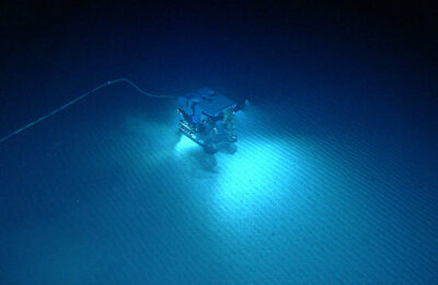
Community assessment was done using video and photographs collected by ROV Sonne in 2007. The images photographed 2 locations on the ridge (Figure 1 in the original article shows transects on Carlsberg Ridge). Both focus areas include off axial highs (mounds), valley walls, and a floor. Images were taken from 1-5 meters about the seafloor. Individuals were included in the quantification analysis if they were greater than 1cm in size when measured from a distance of 2.5 meters above. Table 2 in the original article summarizes the numerous transects by name, location, area size, temperature, transect length, number of individuals identified, and the number of taxa represented. Fauna identification was only to the taxon level because of limitations of details captured in the photographs; species identification was not reliable.
The substratum on the outcrop was divided into 8 types based on geomorphology and composition. For instance, the type of basalt present, the degree of sediment cover, and the percentage of cobble are all factors impacting substratum categorization. Areas used for the density analyses were calculated from the length of the transects and the width of the transects. Transect width was determined from laser scalars and ROV altitude.
How the assemblage varied with bottom type and depth was statistically analyzed by identifying how multiple variables (factors) were alike and different between transects.
What they found:
The two focus areas were split into three sections based on geomorphology: off axial highs (shallow), the valley walls, and the rift floor (deep). The off axial highs had a combination of gradually sloped sections with basalt blocks, sediment covered bases of basalt walls, talus on broken pillow fragments at the base of scarps and small mounds, and some thick pillow mounds with light sediment cover. The walls primarily were cracked pillows with light sediment cover on the ledges. The deep valley floor had the highest variability of substratum, hosting all 8 of the bottom types defined by the researchers. Substratum types in the focus areas are described in Figure 2 and Table 2 of the original article. The main two groups of substratum identified were basalt with cobble and sediment, found in shallow areas, and sediment, which was found in deeper regions.
With regards to fauna, the number of individuals and the assemblage densities varied with depth. In the shallow off-axis areas 272 individuals were noted, representing 19 taxa. The density range was 61-171 individuals per 1000 square meters (average 116 +/- 55). In the mid-depth areas 1632 individuals were observed, representing 69 taxa. The density range was 6-54 individuals per 1000 square meters (average 24 +/- 15). In the deepest areas 186 individuals were counted, representing 22 taxa. The density range was 8-35 individuals per 1000 square meters (average 21 +/- 5). The greatest densities were in the shallow regions and the lowest was in the deepest section surveyed.

The types of faunal groups present at each depth segment also varied. The five main groups identified were Porifera, Cnidaria, Echinodermata (Figure 1), Anthropoda, and Chordata. Typical on off-axial highs were Cnidarians, Poriferans, and Echinoderms. The middle depth group (valley walls) hosted primarily Echinoderms and the deeper regions were dominated by Porifera (Table 3 summaries the abundance range in the three depth segments).
Discussion:
The decrease in assemblage density with depth is typical of deep ocean assemblages. The change is attributed to the availability of food being less in deeper areas. The variability is also associated with the availability of substrate types, some organisms prefer hard versus soft bottoms to attach to, and the presence of strong currents (which usually carry food and also flush the organisms).
Mapping organisms on sections of the seafloor for which there is already available image and video documentation is a great way to learn about who is living on the Earth. Understanding their distributions relative to the environment can help aid in deciphering the relationship between biological community and geochemical environments. And of course, the information about animals present from investigations like this one can be added to the global Census of Marine Life (CoML) to try and create a more complete picture of Earth’s biosphere.
Hello, welcome to Oceanbites! My name is Annie, I’m a marine research scientist who has been lucky to have had many roles in my neophyte career, including graduate student, laboratory technician, research associate, and adjunct faculty. Research topics I’ve been involved with are paleoceanographic nutrient cycling, lake and marine geochemistry, biological oceanography, and exploration. My favorite job as a scientist is working in the laboratory and the field because I love interacting with my research! Some of my favorite field memories are diving 3000-m in ALVIN in 2014, getting to drive Jason while he was on the seafloor in 2017, and learning how to generate high resolution bathymetric maps during a hydrographic field course in 2019!

