The Polar Vortex and Bomb Cyclones
The polar vortex, bomb cyclones – real things, or products of the fake news media? Trust me, they’re real. You’ve probably heard of the polar vortex: a low-pressure, spinning atmospheric system centered near the North Pole that is capable of dipping down to mid-latitudes and causing extreme cold (see Figure 1). Maybe more recently, you’ve heard of bomb cyclones that can cause cold spells and pile up snow across the U.S. East Coast. What’s the difference between the two? Who cares? They both make us despise winter even more.
For starters, we have to get used to them. Although we’re mainly guarded from the effects of the polar vortex by the jet stream (a strong air current that acts as a barrier of wind flowing from west to east that retreats towards the North Pole in the summer), the frigid Arctic air masses find their way down to us when the stream spreads south in the winter, wiggling around as its strength fluctuates.
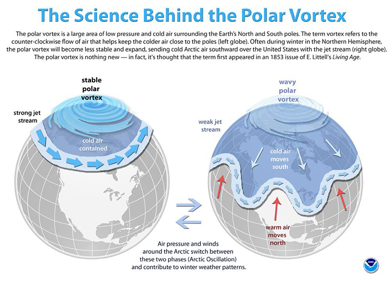
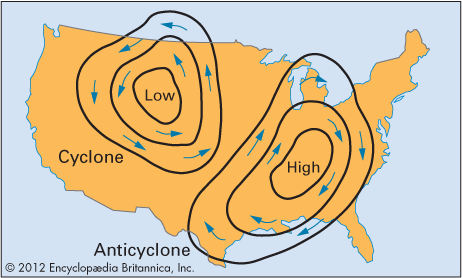
The jet stream is caused by thermal wind, which is just what it sounds like – wind created from temperature differences in the atmosphere. Warm air produces high pressure, cold air produces low pressure, and air flows from high to low pressure. The Coriolis force, which is an apparent force due to the rotation of the Earth, causes poleward airflow to deflect to the right in the Northern hemisphere, resulting in west-to-east movement. The wiggles that form in the jet stream are capable of breaking off and forming cyclones or anticyclones – rings of air that spin counterclockwise or clockwise around a low or high pressure center – and are associated with most of the weather systems we experience (see Figure 2 below).
That’s when the bomb cyclone comes in – basically, a revved up extratropical cyclone. These low-pressure weather systems look a lot like hurricanes at first glance, but their dynamics are different; they gain strength from sharp temperature gradients, whereas tropical cyclones suck up ocean heat as warm systems. Also, tropical cyclones get names, which is not fair. Let’s call our most recent bomb cyclone “Nancy.”
An extratropical cyclone intensifies into a bomb cyclone through bombogenesis, described here. It happened more than once this winter along the U.S. East Coast, the most recent one (Nancy) happening in early March. When warm air over the Gulf Stream collided with frigid Arctic air over land, BOOM. Nancy grew up. For more information on this season’s bomb cyclones and their interactions with the polar vortex, check out this article and video.
Though these processes are probably only relevant to you when you’re suffering through record-breaking low temperatures or trying to dig yourself out of your house-turned-igloo, atmospheric scientists study them all the time to understand how fleeting weather events are impacting climate change, and vice versa.
Atmospheric circulation and climate
A recent study published in Nature Geoscience sought to understand how polar anticyclones (clockwise-spinning rings) contribute to enhanced summertime sea-ice melt, and interestingly, how extratropical cyclones (counterclockwise-spinning rings), ones like Nancy, help form them.
We know that Arctic sea-ice melt is concerning for climate change – in particular, less sea-ice will cause amplified warming in the Arctic due to lower surface albedo (less reflection of radiation from the sun back to space). The Arctic will begin to absorb more of the sun’s heat, which will reduce the temperature gradient between the poles and mid-latitudes, having unknown and possibly dramatic consequences for weather and climate.
First, the paper reviews the two drivers of Arctic sea-ice melt:
1.) Poleward oceanic heat fluxes: the ocean drives warm currents from tropics to poles to redistribute heat; warmer ocean water melts the sea ice on long time scales.
2.) Poleward atmospheric heat fluxes: cyclones and anticyclones help transport air masses containing heat and moisture poleward; warm, moist air melts ice and increases humidity and clouds, causing an enhanced greenhouse effect on short time scales.
This study is primarily focused on the second one. A global dataset of atmosphere and ocean parameters was used to find patterns within the atmosphere to explain how atmosphere dynamics affect sea-ice. The dataset is called ERA-Interim reanalysis data, derived from a model that provides a “best guess” estimate of weather and ocean conditions, adapted based on a range of observational and model data – a common practice among meteorologists forecasting the weather.
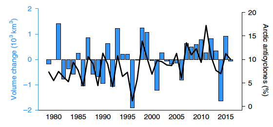
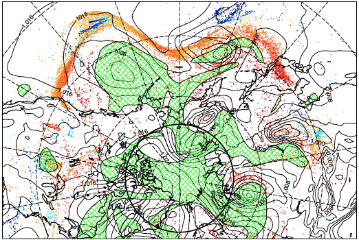
The data revealed that Arctic sea-ice has reduced since the late 1970s, specifically since 1996, and that this is highly correlated with anticyclonic circulation anomalies (circulation that deviates from the average strongly cyclonic circulation of the Arctic) – see Figure 3. This means that the typical counterclockwise rotation of the polar vortex is weakened by sporadic clockwise-spinning systems formed in the Arctic.
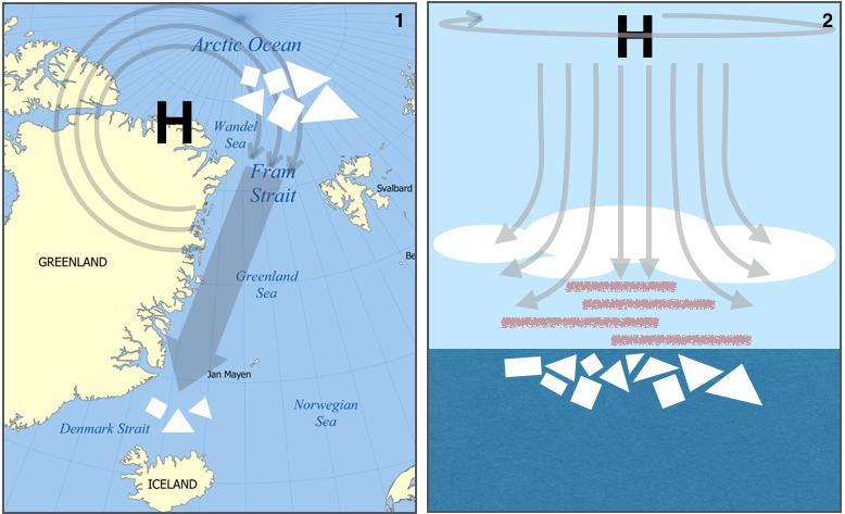
How does this affect sea ice? The paper describes two mechanisms (see Figure 4 below):
1.) Wind-induced export of sea-ice out of the Arctic, and subsequent melting outside.
2.) Increased downwelling of moist upper-atmosphere air, which warms air parcels as they descend to higher pressures and produces low-level clouds which trap heat.
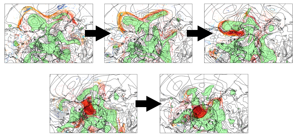
By tracing the trajectories of air parcels, these scientists monitored the development of a polar anticyclone in summer 2007, finding striking evidence that a mid-latitude extratropical cyclone had diverted a mid-latitude airstream into the Arctic (Figure 5). This airstream experienced intense latent heating (or evaporation) in which ocean heat was absorbed into water vapor. As the warm, moist air ascended the atmosphere approaching the Arctic, it gained clockwise-spinning (anticyclonic) momentum, stimulating the development of a polar anticyclone that contributed to enhanced sea-ice melt as the warm air finally descended.
Synthesis
While scientists admit they can’t predict the change in frequency of extratropical cyclones (or tropical cyclones) as the climate changes, there is strong evidence to suggest that these weather systems could become more intense as the ocean warms. In particular, amplified warming in the Arctic will alter the north-south temperature gradient that controls the polar vortex, thus affecting the wiggles that can turn into cyclones and anticyclones. When one of these cyclones approaches the East Coast in the winter, the frigid air over land will collide with the warmer ocean air, driving more frequent and more rapid intensification in the winter (bombogenesis).
This paper has helped add to the conversation about the coupling between these weather systems and climate by showing evidence that they can impact climate by enhancing high latitude temperatures. However, the effect is unclear due to their vastly different timescales; cyclones and anticyclones might last a week at most, while climate changes over hundreds and thousands of years. If climate controls the intensity of these fleeting systems, and they in turn affect warming trends, how will this feedback amplify climate change? Or will it? It’s a puzzling, cyclical question that scientists hope to tackle by including the effects of these storms in long-term climate prediction models. While the polar vortex has begun to wreak havoc on our winters more often by forcing its frigid air into our lives, we must remember the effect humans have on our weather, and in turn on its stability. Poor polar vortex!
I’m a PhD student at the University of Rhode Island’s Graduate School of Oceanography. I use a small-scale computer model to study how physical features like surface waves at the air-sea interface produce friction for the wind that can limit momentum, energy, gas, and heat exchange between the ocean and atmosphere. In the future, I hope to learn more about the role waves play in different parts of the world as weather and climate patterns evolve. Also, I love to write.
