Kent, G.M., Arnulf, A.F., Singh, S.C. et al. Melt focusing along lithosphere–asthenosphere boundary below Axial volcano. Nature 641, 380–387 (2025). https://doi.org/10.1038/s41586-025-08865-8
Earth is a complex avocado
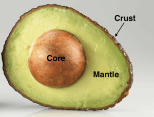
You may remember at some point learning about the layers of the Earth from the outside to the interior: the crust, mantle, and core. One could cut open an avocado and find similar layers that do a good job representing our planet. The skin of the avocado is the crust, the green part we eat is the mantle, and the pit is the core (Figure 1). However, there are additional layers and characteristics that make the inside of the Earth more complex. These layers can be defined by variables like temperature, composition (what something is made of), and whether the layer is solid or liquid. All these characteristics and how they may change, or interact, over time play a part in melting the inside of the Earth to create magma.
Making ~Waves~
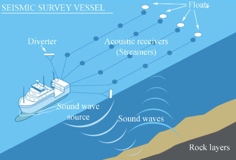
Kent and his team take advantage of these differences to image the inside of the planet using seismic waves, or vibrations that can be sent through the Earth. There are two types of seismic waves: P-waves and S-waves. P-waves are faster and can move through both solid and liquid material, while S-waves are slower and can only move through solids. Therefore, if you are tracking these waves through a region and the S-waves are lost at a certain time, it can be assumed that there is liquid at the corresponding depth.
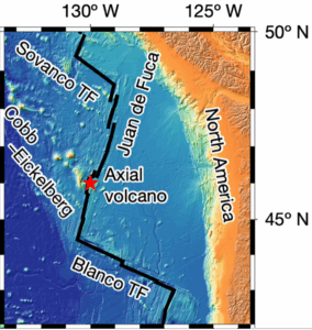
Aboard the Research Vessel Marcus Langseth, Kent and his team used 3D seismic wave reflections to create an image of the region beneath Axial Volcano, an underwater volcano off the coast of the Pacific Northwest (PNW) of the United States (Figure 2). Axial is a highly monitored volcano that sits ~1400 meters (~4593 feet) beneath the surface of the ocean. Thanks to monitoring efforts and frequent visits from oceanographic researchers, we know Axial has erupted three times in the last 30 years (1998, 2011, 2015).
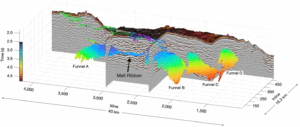
The team found strong, funnel-shaped reflections using seismic waves in four areas beneath Axial and named them Funnels A, B, C, and D (Figure 3). The intensity of the reflections suggests there is some melt (magma) in those regions. The curved upper portions of the funnels represent boundaries between the solid and liquid layers of the Earth. The solid layer is colder than the liquid layer. This is the first time these funnel shapes have been imaged, and it is possible that they help guide magma towards the surface to be erupted. The scientists also discovered a large, flat layer (ribbon) of melt connecting Funnels A and B beneath the main volcano where the last three eruptions began, leading them to believe this ribbon is the main source of eruptions at Axial.
Imminent Eruption?
This study is important because it images new shapes associated with the boundary between two layers of the Earth where melting and magma production can occur. The shape, location, and characteristics of these different layers (hot and liquid vs. cold and solid) may explain some of the differences in the erupted lavas at Axial and may lead to a better understanding of similar volcanic locations like Iceland. Lastly, Kent and his team point out that stronger reflections may indicate more liquid present, and therefore more magma production, suggesting Axial may be gearing up for another eruption. Imaging the inside of the planet beneath volcanoes on a consistent basis may be a good way to track and predict future eruptions. This could improve safety related to volcanic activity by refining early warning systems and increasing evacuation time for people living around volcanoes.
Cover photo from Asuelimen et al., 2020 and references therein.
I am a Ph.D. Candidate in Geological Oceanography at the University of Rhode Island, Graduate School of Oceanography. I received my B.S. in Geology from Union College (NY). I study submarine volcanoes! I use the chemical composition of lava to figure out what is happening inside the Earth and how magma is formed. When I’m not working with rocks, I enjoy reading on the beach, cooking, and hiking.
A volcano can be under the ocean!? Thanks for simplifying this along with the addition of good figures to explain it to us non-scientists.