Fichefet, J., De Loose, E., Dudley, R., Martin, G., Tully, O., Berrow, S. Assessing the risk of whale entanglement in pot fisheries in Irish waters. Front. Mar. Sci.13, 1749710. (2026). https://doi.org/10.3389/fmars.2026.1749710
A recent study by Fichefet and colleagues mapped where whales and pot fishing gear are most likely to overlap in Irish waters, revealing hotspots of entanglement risk and where conservation efforts may matter most.
Pot Fishing and Whale Entanglement
Pot fishing is a commercial and recreational fishing method that uses baited cages or baskets, often made of wire or wood, to trap shellfish and fish on the seafloor. These traps allow animals to enter easily but make escape difficult or impossible. Compared to large trawls, which can result in significant bycatch, pot fishing may seem relatively harmless.
However, pot fishing is passive. The baited cages sit on the seafloor, and fishers later retrieve them using ropes that connect them to surface buoys (known as vertical lines). Depending on the size of the pot fishing operation, traps may be set individually or linked together in long strings by other ropes called groundlines.
While the ropes make it easy for fisherman to relocate their cages, these same ropes create a vertical maze in the water. Large whales can become entangled in these lines, with rope wrapped around their fins, tails, or mouths, especially in areas where their feeding grounds overlap with fishing activity. Entanglement can restrict movement, lead to serious injury, and often ultimately death.
Although commercial whaling protections have allowed whale populations to recover and increase, fishing activity has also expanded over time. These simultaneous increases result in a growing risk of entanglement for large whales.
Whales in Irish Waters
Large whales play a key role in the environment. In the coastal waters of Ireland, whale populations are dispersed all around the island. So far, 26 different cetacean species have been recorded in Irish waters, but the three whale species that dominate are minke, fin, and humpback whales. These whales use the Irish waters to feed; however, the active fisheries in the Irish waters create an overlap of whales and gear.
Understanding Entanglement Risk
Previous studies have assessed whale entanglement risk in Irish waters, but many have overlooked a key factor: small boats. Boats less than 12 meters in length make up about 85% of the Irish fleet, and they typically use pot fishing gear. However, unlike larger vessels, they are not required to carry Vessel Monitoring Systems (VMS), which makes their activity harder to track.
To overcome these gaps, Fichefet and their team combined multiple datasets, including larger vessel data and other landings information, to estimate fishing effort. Following the work of previous studies, they then calculated the “risk of entanglement measure (REM).” The REM index ultimately identifies the areas where whale presence and fishing activity overlap most strongly and could lead to entanglement.
So where are the whales?
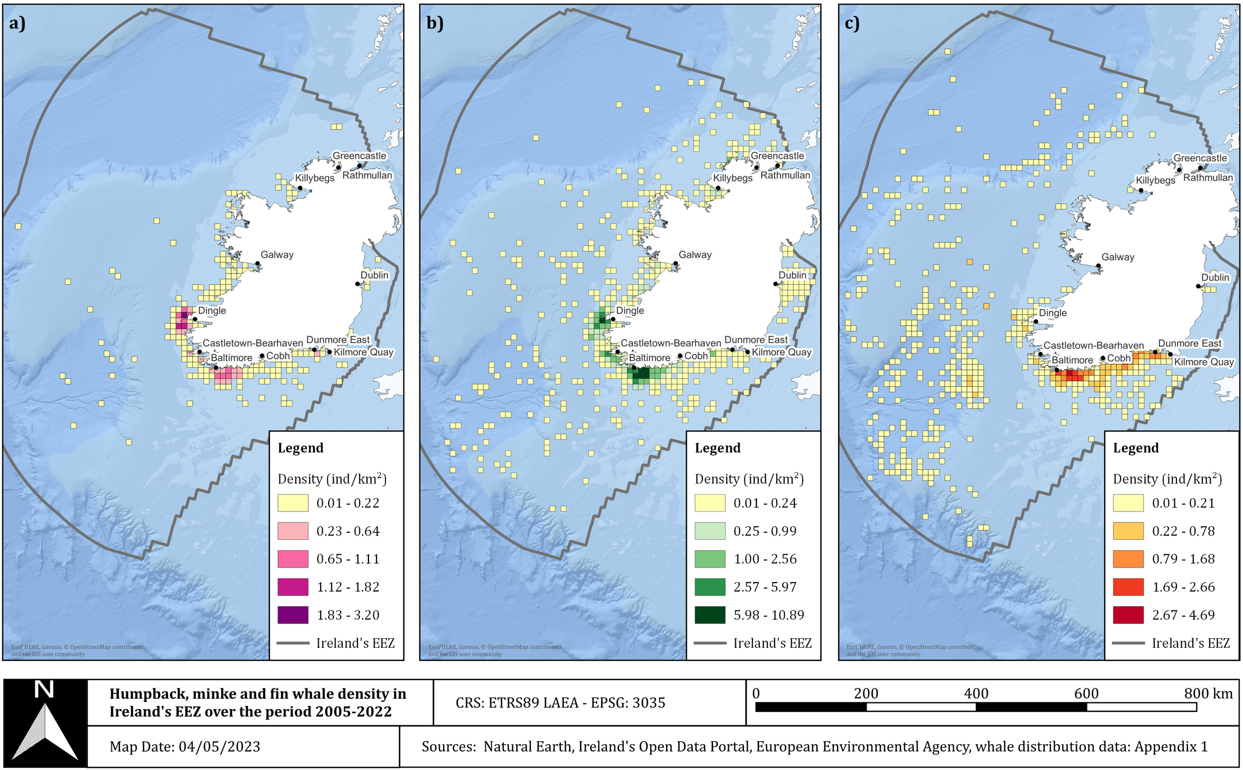
Using whale sighting records from 2005 – 2022, researchers found that the highest whale densities occurred off Ireland’s south and southwest coasts for humpback, minke, and fin whales (Figure 1). Minke whales were found to be the most abundant. While all three whale species were present year-round, the peak seasons differed by species. Humpback whales peaked July – September, minke whales peaked May – July, and fin whales peaked September – November.
And where is the fishing happening?
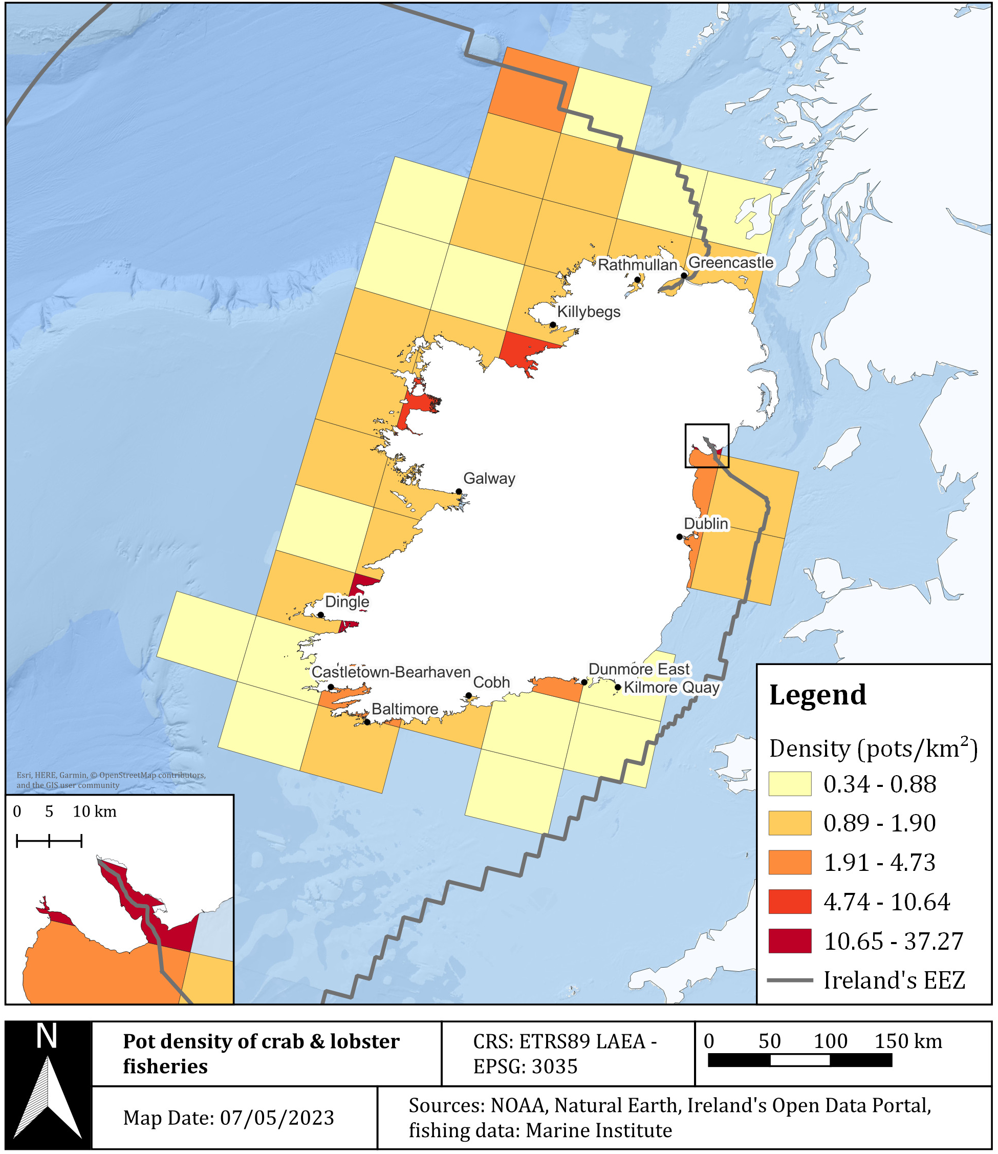
The researchers then looked at both fishing effort, measured as hours spent fishing per year, and available density of pots per kilometer squared. Between both approaches to quantify fishing, the results agreed that effort was highest in Ireland’s north coast, east coast, and southwest coast (Figure 2).
Mapping Entanglement Risk
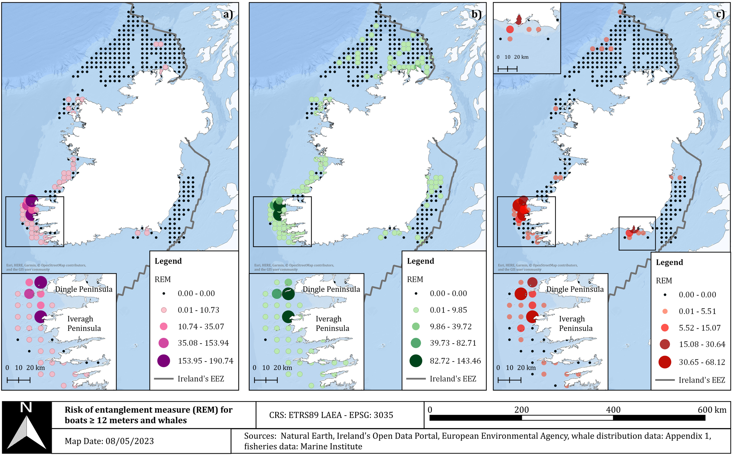
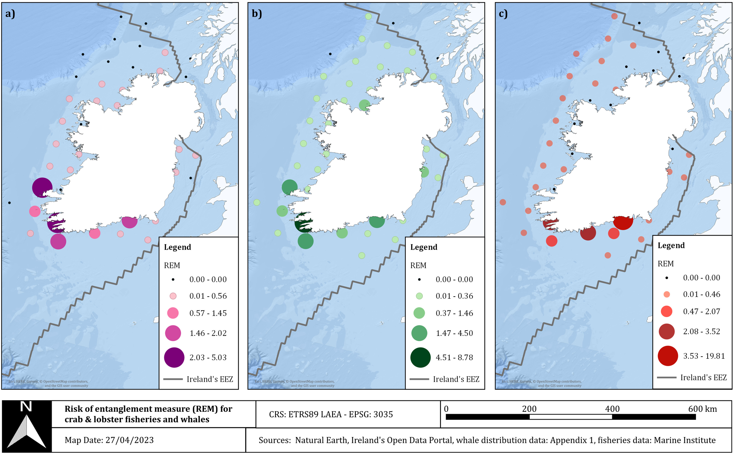
By combining whale density with fishing effort, the REM index revealed clear hotspots of entanglement risk. Ireland’s southwest coast showed the highest overall risk, particularly for boats over 12 meters in length (Figure 3). Minke whales had a broader risk distribution, stretching into the northern and eastern waters compared to the other whale species. Humpback whale risk was concentrated in the southwest and south, and fin whales showed elevated risk along the south coast. Similarly, for vessels under 12 meters in length, the trends were very similar (Figure 4). Overall, the areas of highest entanglement risk closely matched regions with both high whale density and high fishing activity.
Implications for Conservation
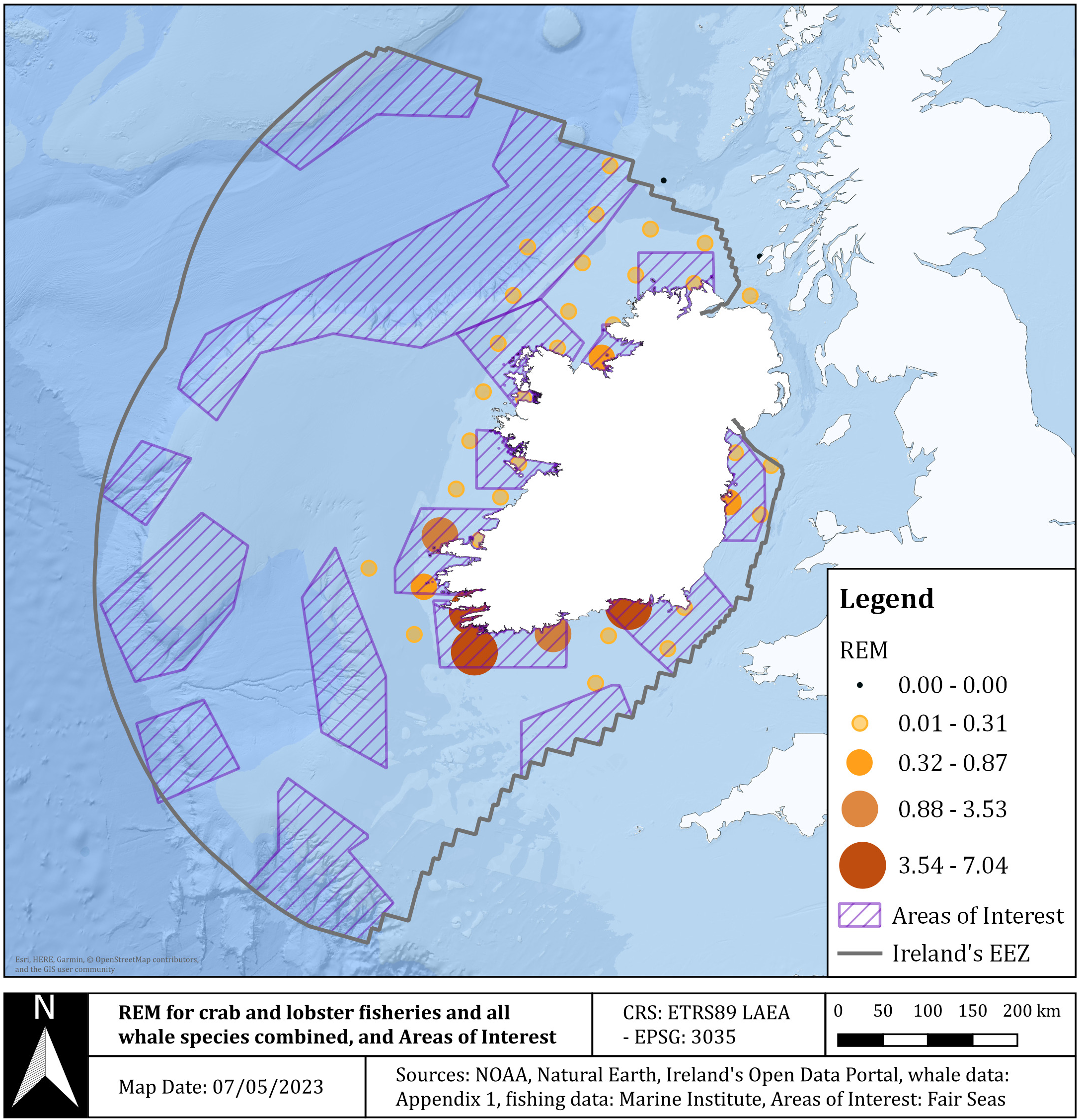
Importantly, the study found that areas with high REM values often overlapped with Areas of Interest (AoI) identified for potential Marine Protected Areas (MPAs) for cetaceans (Figure 5). Entanglement risk was highest in late spring and summer, with the southwest coast of Ireland emerging as a priority area for potential mitigation strategies. These results indicate that entanglement risk should be a key consideration in future MPA planning. By mapping where whales and fisheries overlap, this research provided several tools that can be used to guide smarter and more effective conservation strategies in Irish waters.
Acknowledging Data Gaps
Nevertheless, like many large-scale ecological studies, this work relied on some opportunistic data, which does introduce bias. Whale sightings are more common in coastal and well-traveled areas, and offshore regions remain under-sampled. Because fin whales surface less frequently, they may be harder to detect and may be underreported. At the same time, humpback whales have been reported to survive some entanglements, unlike the smaller minke whales. In addition, Ireland currently lacks a post-mortem program to determine cause of death in cetaceans, and the total fishing effort, especially from smaller vessels, is likely underestimated.
Despite these limitations, the study highlights the growing value of citizen science and opportunistic sighting data in marine research as well as opportunities to reform fishing efforts to collect meaningful data.
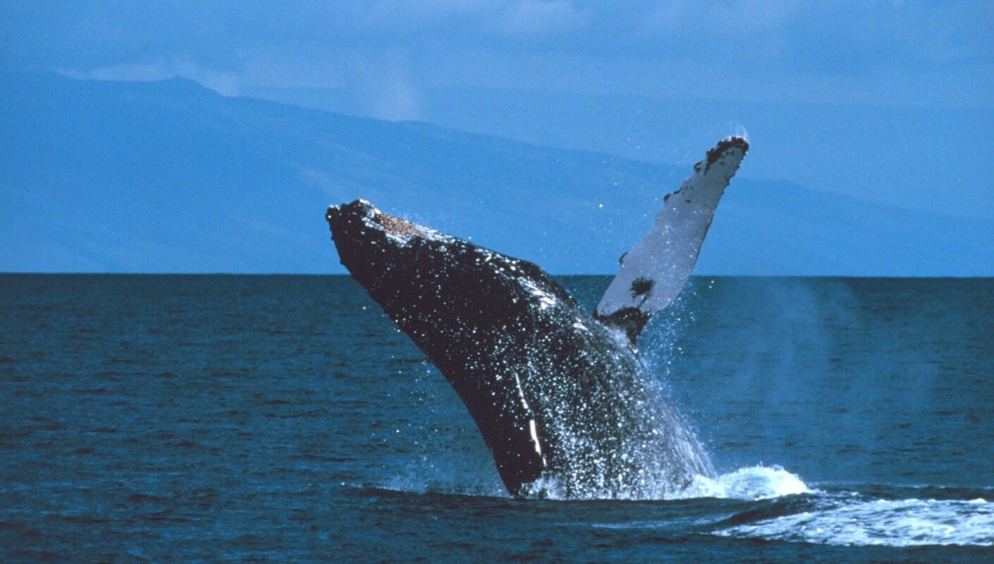
Cover image is a humpback whale breaching in the Hawaiian Islands Humpback Whale National Marine Sanctuary. Photograph was taken by Stan Butler and obtained from the NOAA Public Domain Library.
I am a Ph.D. Candidate at the University of Connecticut–Avery Point studying the marine carbonate system in the Arctic Ocean. My research focuses on biogeochemical changes occurring within sea ice as the Arctic continues to warm. Outside of my research, I enjoy hiking, running, aerial gymnastics, paddleboarding, traveling, and spending time with family and friends.